|
For notes on how to interpret
the data and quality control issues, see Daily Weather Summary Help.
**S** and **W** precede data flagged by the Bureau as suspicious or wrong
Data is as received at 00:57EST, 15/05/2012.
|
|
| |
Max
°
C |
+/- norm
°
C |
Min
°
C |
+/- norm
°
C |
Grass Min
°
C |
Rain to 9am mm |
Evaporation to 9am mm |
Sunshine hours |
Wind Run to 9am km (24-hour average km/h) |
Maximum Gust km/h / hour of occurrence |
| GERALDTON AIRPORT |
25.5 |
+6.0 |
9.3 |
-0.2 |
6.2 |
0.0 |
4.6 |
-- |
410 (17.1) |
37/03 |
| PERTH AIRPORT |
19.3 |
+1.4 |
6.2 |
-1.9 |
4.0 |
0.0 |
1.8 |
9.6 |
253 (10.5) |
61/10 |
| ALBANY AIRPORT |
16.0 |
+0.2 |
5.9 |
-1.6 |
4.0 |
6.6 |
1.8 |
8.1 |
220 ( 9.2) |
24/10 |
| BUNBURY |
18.3 |
+1.1 |
8.0 |
+0.8 |
-- |
0.0 |
-- |
-- |
162 ( 6.8) |
24/12 |
| MANDURAH |
18.8 |
-- |
9.0 |
-- |
-- |
0.0 |
-- |
-- |
168 ( 7.0) |
30/11 |
| DARWIN AIRPORT |
31.1 |
+0.6 |
19.4 |
+0.2 |
18.4 |
0.0 |
5.8 |
11.0 |
355 (14.8) |
41/13 |
| ALICE SPRINGS AIRPORT |
20.3 |
+0.6 |
1.7 |
-2.3 |
-2.1 |
0.0 |
3.4 |
10.4 |
212 ( 8.8) |
35/12 |
| WHYALLA AERO |
15.7 |
-1.2 |
6.8 |
+1.5 |
-- |
0.0 |
2.8 |
-- |
393 (16.4) |
44/10 |
| ADELAIDE (KENT TOWN) |
12.8 |
-2.5 |
8.3 |
+0.8 |
6.3 |
8.8 |
1.6 |
6.1 |
383 (16.0) |
59/17 |
| MOUNT GAMBIER AERO |
9.5 |
-3.6 |
5.3 |
+0.1 |
3.8 |
16.8 |
3.0 |
4.3 |
564 (23.5) |
78/14 |
| MOUNT ISA AERO |
23.5 |
-1.2 |
11.9 |
+3.3 |
9.7 |
0.0 |
4.8 |
6.7 |
297 (12.4) |
37/16 |
| CAIRNS AERO |
26.3 |
+0.6 |
16.3 |
-0.7 |
14.7 |
0.0 |
5.4 |
9.6 |
411 (17.1) |
34/12 |
| TOWNSVILLE AERO |
24.3 |
-0.8 |
10.4 |
-3.2 |
7.9 |
0.0 |
3.8 |
10.3 |
204 ( 8.5) |
28/14 |
| MACKAY M.O |
20.0 |
-1.3 |
10.6 |
-2.2 |
-- |
0.0 |
-- |
7.3 |
305 (12.7) |
26/05 |
| ROCKHAMPTON AERO |
20.0 |
-3.1 |
11.1 |
+1.6 |
10.2 |
0.0 |
2.8 |
-- |
165 ( 6.9) |
22/18 |
| BUNDABERG AERO |
19.7 |
-2.3 |
7.4 |
-2.7 |
-- |
0.0 |
1.2 |
-- |
232 ( 9.7) |
28/14 |
| NAMBOUR DPI |
21.3 |
+0.2 |
2.8 |
-4.9 |
-- |
0.0 |
4.2 |
-- |
34 ( 1.4) |
22/15 |
| COOLANGATTA |
19.7 |
-0.8 |
5.5 |
-4.4 |
-- |
0.0 |
-- |
-- |
143 ( 6.0) |
35/15 |
| BRISBANE AERO |
19.3 |
-1.6 |
4.6 |
-4.2 |
0.0 |
0.0 |
2.2 |
10.0 |
254 (10.6) |
30/00 |
| TOOWOOMBA AIRPORT |
15.0 |
-1.6 |
1.2 |
-5.1 |
-- |
0.0 |
-- |
-- |
307 (12.8) |
-- |
| GUNNEDAH RESOURCE CENTRE |
12.7 |
-3.4 |
-2.3 |
-7.0 |
-5.3 |
0.0 |
1.8 |
-- |
82 ( 3.4) |
-- |
| COFFS HARBOUR MO |
18.7 |
0.0 |
2.1 |
-5.4 |
-2.2 |
0.0 |
1.6 |
9.9 |
168 ( 7.0) |
35/12 |
| PORT MACQUARIE AIRPORT AWS |
17.8 |
-0.9 |
2.2 |
-4.1 |
-- |
0.0 |
-- |
-- |
-- |
-- |
| WILLIAMTOWN RAAF |
14.3 |
-2.7 |
0.7 |
-5.6 |
-3.6 |
0.0 |
3.0 |
8.4 |
329 (13.7) |
58/13 |
| GOSFORD (NARARA RESEARCH STATION) AWS |
15.3 |
-2.2 |
-1.5 |
-6.1 |
-- |
0.2 |
-- |
-- |
36 ( 1.5) |
31/10 |
| ORANGE AGRICULTURAL INSTITUTE |
5.2 |
-4.1 |
-5.5 |
-6.9 |
-8.0 |
0.0 |
2.8 |
6.0 |
-- |
-- |
| DUBBO AIRPORT AWS |
11.6 |
-3.6 |
-4.1 |
-7.1 |
-- |
0.2 |
-- |
-- |
-- |
-- |
| SYDNEY AIRPORT AMO |
15.3 |
-1.7 |
3.0 |
-4.1 |
-2.1 |
0.0 |
2.8 |
10.1 |
318 (13.3) |
39/21 |
| RICHMOND RAAF |
14.4 |
-3.0 |
-3.4 |
-6.9 |
-- |
0.2 |
-- |
-- |
34 ( 1.4) |
37/15 |
| BELLAMBI AWS |
14.5 |
-2.3 |
4.1 |
-5.9 |
-- |
0.0 |
-- |
-- |
239 (10.0) |
43/14 |
| CANBERRA AIRPORT |
7.3 |
-4.0 |
-4.7 |
-4.6 |
-7.2 |
0.0 |
0.8 |
5.7 |
217 ( 9.0) |
52/14 |
| WAGGA WAGGA AMO |
11.8 |
-0.9 |
0.8 |
-1.9 |
-0.9 |
0.0 |
0.0 |
2.2 |
87 ( 3.6) |
71/16 |
| ALBURY AIRPORT AWS |
11.1 |
-1.9 |
2.0 |
-1.2 |
-- |
0.0 |
-- |
-- |
72 ( 3.0) |
61/15 |
| MILDURA AIRPORT |
13.8 |
-1.5 |
4.6 |
+0.3 |
-0.7 |
0.0 |
1.2 |
4.9 |
372 (15.5) |
76/10 |
| TATURA INST SUSTAINABLE AG |
8.5 |
-4.5 |
3.5 |
+0.6 |
-- |
0.0 |
1.5 |
-- |
365 (15.2) |
50/12 |
| BENDIGO AIRPORT |
8.4 |
-4.1 |
3.8 |
+1.4 |
-- |
0.0 |
-- |
-- |
-- |
�
41/16 |
| MELBOURNE REGIONAL OFFICE |
9.2 |
-4.2 |
7.0 |
+1.0 |
3.3 |
0.0 |
3.0 |
-- |
238 ( 9.9) |
39/08 |
| GEELONG AIRPORT |
9.6 |
-4.2 |
6.1 |
+0.7 |
-- |
2.4 |
-- |
-- |
630 (26.3) |
67/13 |
| BALLARAT AERODROME |
7.0 |
-3.0 |
0.4 |
-2.8 |
-- |
4.4 |
-- |
-- |
776 (32.3) |
58/06 |
| LAUNCESTON (TI TREE BEND) |
9.3 |
-3.3 |
2.5 |
+0.3 |
-- |
11.2 |
-- |
-- |
483 (20.1) |
61/06 |
| HOBART AIRPORT |
9.1 |
-3.3 |
5.9 |
+1.8 |
5.8 |
0.0 |
0.8 |
0.0 |
410 (17.1) |
59/03 |
| |
Max
°
C |
+/- norm
°
C |
Min
°
C |
+/- norm
°
C |
Grass Min
°
C |
Rain to 9am mm |
Evaporation to 9am mm |
Sunshine hours |
Wind Run to 9am km |
Maximum Gust km/h / hour of occurrence |
|
| Hottest |
| Highest maximum temperature> | Greatest variation above normal maximum |
Highest minimum temperature | Greatest variation above normal minimum |
32.9 JABIRU AIRPORT N Rivers NT
32.3 KURI BAY N Kimberley WA
32.2 BATCHELOR AERO N Rivers NT
32.1 WEST ROEBUCK W Kimberley WA
32.1 MIDDLE POINT AWS N Rivers NT
|
+8.4 : 30.1 KALBARRI Central West WA
+6.5 : 25.2 MULLEWA Central West WA
+6.4 : 28.7 CARNARVON AIRPORT W Gascoyne WA
+6.0 : 25.5 GERALDTON AIRPORT Central West WA
+5.8 : 27.6 DENHAM W Gascoyne WA
+5.8 : 28.6 SHARK BAY AIRPORT W Gascoyne WA
|
24.5 COCOS ISLAND AIRPORT Islands ISL
23.6 COCONUT ISLAND N Peninsula QLD
23.5 CHRISTMAS ISLAND AERO Islands ISL
23.0 TROUGHTON ISLAND N Kimberley WA
22.3 WILLIS ISLAND Islands ISL
|
+6.7 : 20.5 BIDYADANGA W Kimberley WA
+6.6 : 20.0 KALUMBURU N Kimberley WA
+5.6 : 14.9 GASCOYNE JUNCTION W Gascoyne WA
+5.5 : 17.5 WEST ROEBUCK W Kimberley WA
+4.8 : 16.5 ONSLOW W Pilbara WA
|
| Coldest |
| Lowest maximum temperature | Greatest variation below normal maximum |
Lowest minimum temperature | Greatest variation below normal minimum |
-4.6 MT HOTHAM Upper NE VIC
-4.1 THREDBO AWS Snowy Mtns NSW
-4.0 MOUNT GININI AWS Goulburn/Monaro NSW
-3.8 FALLS CREEK Upper NE VIC
-3.5 MOUNT BULLER Upper NE VIC
|
-6.4 : 8.2 SWAN HILL AERODROME Mallee S VIC
-5.8 : 17.4 BARALABA POST OFFICE Wide Bay/Burnett QLD
-5.8 : -2.0 CABRAMURRA SMHEA AWS SW Slopes S NSW
-5.4 : 13.4 INGLEWOOD FOREST Darling Downs E QLD
-5.2 : 0.0 THREDBO VILLAGE Snowy Mtns NSW
-5.2 : 3.9 EILDON FIRE TOWER N Central VIC
-5.2 : 7.1 DOVER Southeast TAS
|
-12.1 CHARLOTTE PASS (KOSCIUSKO CHALET) Snowy Mtns NSW
-11.0 PERISHER VALLEY SKI CENTRE Snowy Mtns NSW
-9.6 GLEN INNES AIRPORT AWS N Tablelands W NSW
-9.0 THREDBO AWS Snowy Mtns NSW
-8.4 ARMIDALE (TREE GROUP NURSERY) N Tablelands W NSW
|
-9.6 : -4.5 TAROOM POST OFFICE Central Highlands QLD
-8.6 : -3.7 ST GEORGE AIRPORT Maranoa QLD
-8.4 : -4.4 DALBY AIRPORT Darling Downs E QLD
-8.3 : -3.7 GOONDIWINDI AIRPORT Darling Downs E QLD
-8.3 : -9.6 GLEN INNES AIRPORT AWS N Tablelands W NSW
|
|
Sunniest &
dullest |
Windiest |
Highest gusts |
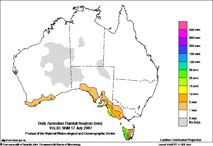
Todays highest rainfall totals for the 24 hours to 9am. It
includes the top 5 totals nationally followed by all reported falls of 50mm or more. |
Highest
and lowest recordings of hours of sunshine for the 24 hours to midnight. |
Highest wind
run totals in kilometres for the 24 hours to 9am (average speed in brackets).
All reported runs >
=25km/h are shown. |
Highest wind
gusts in km/h for the 24 hours to midnight followed by the hour in which it occurred.
All stations with gusts >
89km/h are shown. |
60.0 STRATHGORDON (GORDON POWER STATION) W Coast TAS
52.0 STRATHGORDON VILLAGE W Coast TAS
49.4 BREONA (LOWER HAULAGE ROAD) Central Plateau TAS
44.4 QUEENSTOWN (SOUTH QUEENSTOWN) W Coast TAS
43.0 STRAHAN AERODROME W Coast TAS
TASMANIA
Central Plateau
49.4 BREONA (LOWER HAULAGE ROAD)
W Coast
60.0 STRATHGORDON (GORDON POWER STATION)
52.0 STRATHGORDON VILLAGE
44.4 QUEENSTOWN (SOUTH QUEENSTOWN)
43.0 STRAHAN AERODROME
|
11.0 DARWIN AIRPORT N Rivers NT
10.8 GILES METEOROLOGICAL OFFICE Interior WA
10.4 ALICE SPRINGS AIRPORT N Plateau NT
10.3 GOVE AIRPORT N Rivers NT
10.3 TOWNSVILLE AERO N Coast--Herbert QLD
.....
0.0 LAKE EILDON N Central VIC
0.0 SCOTTSDALE (WEST MINSTONE ROAD) N Coast TAS
0.0 LAKE LEAKE (ELIZABETH RIVER) E Coast TAS
0.0 HOBART AIRPORT Southeast TAS
0.0 GROVE (COMPARISON) Southeast TAS
0.0 LIAWENEE Central Plateau TAS
|
1251 (52.1) MOUNT WELLINGTON Southeast TAS
1246 (51.9) MAATSUYKER ISLAND LIGHTHOUSE Southeast TAS
1237 (51.5) NEPTUNE ISLAND W Agricultural SA
1223 (51.0) HOGAN ISLAND Islands ISL
1208 (50.3) SWAN ISLAND E Coast TAS
1196 (49.8) LOW HEAD N Coast TAS
1192 (49.7) COLAC (MT GELLIBRAND) W Coast VIC
1123 (46.8) KING ISLAND AIRPORT King Island TAS
1079 (45.0) DEVONPORT AIRPORT N Coast TAS
1062 (44.3) CAPE WILLOUGHBY Yorke Pen/Kanga Is SA
1057 (44.0) MOUNT READ W Coast TAS
986 (41.1) RHYLL E Central VIC
985 (41.0) THREDBO AWS Snowy Mtns NSW
970 (40.4) CAPE JAFFA (CURLEY HILLS) Lower SE SA
950 (39.6) SCOTTS PEAK DAM W Coast TAS
923 (38.5) KILMORE GAP N Central VIC
910 (37.9) CAPE GRIM BAPS N Coast TAS
901 (37.5) CAPE BORDA AWS Yorke Pen/Kanga Is SA
896 (37.3) EDDYSTONE POINT E Coast TAS
869 (36.2) DUNNS HILL E Central VIC
827 (34.5) STENHOUSE BAY Yorke Pen/Kanga Is SA
826 (34.4) AIREYS INLET W Coast VIC
820 (34.2) VARANUS ISLAND Islands ISL
806 (33.6) CAPE OTWAY LIGHTHOUSE W Coast VIC
799 (33.3) MELBOURNE AIRPORT E Central VIC
793 (33.0) COULTA (COLES POINT) W Agricultural SA
783 (32.6) LUNCHEON HILL (FORESTRY) N Coast TAS
776 (32.3) BALLARAT AERODROME Western Plains VIC
774 (32.3) FLINDERS ISLAND AIRPORT Flinders Is/Bass St TAS
765 (31.9) ROBE AIRFIELD Lower SE SA
762 (31.8) STRAHAN AERODROME W Coast TAS
743 (31.0) FALLS CREEK Upper NE VIC
734 (30.6) WYNYARD AIRPORT N Coast TAS
728 (30.3) MOORABBIN AIRPORT E Central VIC
718 (29.9) HINDMARSH ISLAND AWS Adelaide/Lofty SA
716 (29.8) CRESSY RESEARCH STATION N Coast TAS
713 (29.7) WARRNAMBOOL AIRPORT NDB W Coast VIC
711 (29.6) WILLIS ISLAND Islands ISL
709 (29.5) HAMILTON AIRPORT W Coast VIC
693 (28.9) SHEOAKS W Central VIC
693 (28.9) CAPE NELSON LIGHTHOUSE W Coast VIC
690 (28.8) LOW ISLES LIGHTHOUSE N Coast--Barron QLD
689 (28.7) PORTLAND (CASHMORE AIRPORT) W Coast VIC
686 (28.6) CAPE FLATTERY N Coast--Barron QLD
684 (28.5) MINLATON AERO Yorke Pen/Kanga Is SA
683 (28.5) SMITHTON AERODROME N Coast TAS
680 (28.3) TASMAN ISLAND Southeast TAS
670 (27.9) MOUNT CRAWFORD FIRE TOWER Adelaide/Lofty SA
670 (27.9) COCOS ISLAND AIRPORT Islands ISL
659 (27.5) MORTLAKE RACECOURSE W Coast VIC
653 (27.2) NORTH SHIELDS (PORT LINCOLN AWS) W Agricultural SA
643 (26.8) LIAWENEE Central Plateau TAS
634 (26.4) ESSENDON AIRPORT E Central VIC
631 (26.3) EDITHBURGH Yorke Pen/Kanga Is SA
630 (26.3) GEELONG AIRPORT W Central VIC
629 (26.2) NORTH ISLAND Central West WA
627 (26.1) SHEFFIELD SCHOOL FARM N Coast TAS
626 (26.1) WILSONS PROMONTORY LIGHTHOUSE W Gippsland VIC
615 (25.6) COONAWARRA Lower SE SA
613 (25.5) PARAWA (SECOND VALLEY FOREST AWS) Adelaide/Lofty SA
612 (25.5) MCCLUER ISLAND N Rivers NT
607 (25.3) LAUNCESTON AIRPORT COMPARISON N Coast TAS
|
118/10 THREDBO AWS Snowy Mtns NSW
113/03 MOUNT WELLINGTON Southeast TAS
111/03 MAATSUYKER ISLAND LIGHTHOUSE Southeast TAS
109/05 HOLSWORTHY CONTROL RANGE Sydney--west NSW
109/21 WILSONS PROMONTORY LIGHTHOUSE W Gippsland VIC
107/12 HOGAN ISLAND Islands ISL
106/01 CAPE GRIM BAPS N Coast TAS
104/11 MT HOTHAM AIRPORT Upper NE VIC
100/03 SCOTTS PEAK DAM W Coast TAS
100/03 MOUNT READ W Coast TAS
96/06 NEPTUNE ISLAND W Agricultural SA
96/05 DUNNS HILL E Central VIC
|
�