Wednesday 27 JUN 2007
 

Home page

DWS ARCHIVE
2024 2023 2022 2021 2020 2019 2018 2017 2016 2015 2014 2013 2012 2011 2010 2009 2008 2007 2006 2005 2004 2003
Before 2003

About the DWS


2007

Dec

M Tu W Th F Sa Su
          01 02
03 04 05 06 07 08 09
10 11 12 13 14 15 16
17 18 19 20 21 22 23
24 25 26 27 28 29 30
31            

Nov

M Tu W Th F Sa Su
      01 02 03 04
05 06 07 08 09 10 11
12 13 14 15 16 17 18
19 20 21 22 23 24 25
26 27 28 29 30    

Oct

M Tu W Th F Sa Su
01 02 03 04 05 06 07
08 09 10 11 12 13 14
15 16 17 18 19 20 21
22 23 24 25 26 27 28
29 30 31        

Sept

M Tu W Th F Sa Su
          01 02
03 04 05 06 07 08 09
10 11 12 13 14 15 16
17 18 19 20 21 22 23
24 25 26 27 28 29 30

August

M Tu W Th F Sa Su
    01 02 03 04 05
06 07 08 09 10 11 12
13 14 15 16 17 18 19
20 21 22 23 24 25 26
27 28 29 30 31    

July

M Tu W Th F Sa Su
            01
02 03 04 05 06 07 08
09 10 11 12 13 14 15
16 17 18 19 20 21 22
23 24 25 26 27 28 29
30 31          

June

M Tu W Th F Sa Su
        01 02 03
04 05 06 07 08 09 10
11 12 13 14 15 16 17
18 19 20 21 22 23 24
25 26 27 28 29 30  

May

M Tu W Th F Sa Su
  01 02 03 04 05 06
07 08 09 10 11 12 13
14 15 16 17 18 19 20
21 22 23 24 25 26 27
28 29 30 31      

April

M Tu W Th F Sa Su
            01
02 03 04 05 06 07 08
09 10 11 12 13 14 15
16 17 18 19 20 21 22
23 24 25 26 27 28 29
30            

March

M Tu W Th F Sa Su
      01 02 03 04
05 06 07 08 09 10 11
12 13 14 15 16 17 18
19 20 21 22 23 24 25
26 27 28 29 30 31  

February

M Tu W Th F Sa Su
      01 02 03 04
05 06 07 08 09 10 11
12 13 14 15 16 17 18
19 20 21 22 23 24 25
26 27 28        

January

M Tu W Th F Sa Su
01 02 03 04 05 06 07
08 09 10 11 12 13 14
15 16 17 18 19 20 21
22 23 24 25 26 27 28
29 30 31        

Monthly summaries:
from BoM

Find a place:
Google Maps |
Aust Gazetteer|
Geonames

Weather terms:
WeatherZone | BoM |
American Met Soc | NOAA | uk.sci.weather | India Meteorological Department

National Daily Weather Summary

Records set | Charts | Cities | Hottest | Coldest | Rain, sun & wind | Downpours & gales
State extremes | Noteworthy weather | Capital Cities | Regional Cities | Alpine Stations
Charts and data courtesy Bureau of Meteorology. MTSAT-1R operated by JMA
Noteworthy weather today
significant newsworthy major
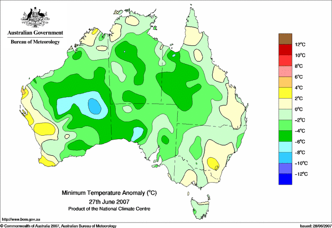
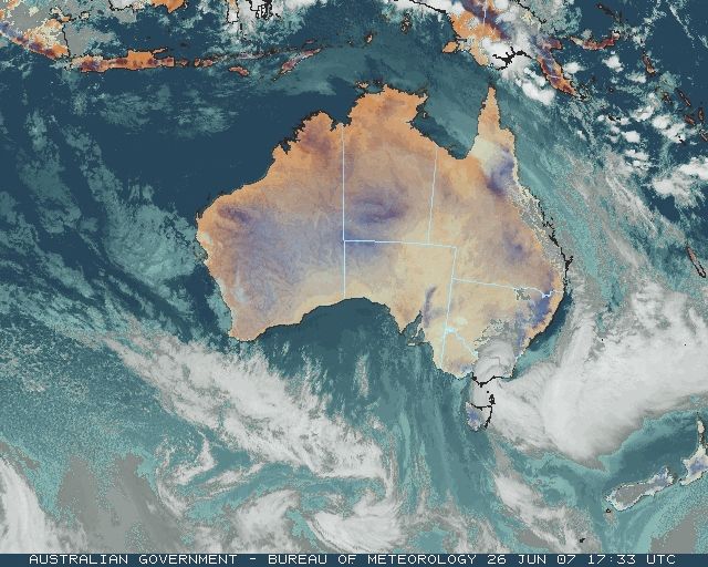
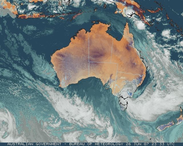
Rainfall and river level maps for today (above), Thursday 28 (below) and Friday 29 June (bottom). The rainfall maps are for the 24 hours to 9am, and the river levels are as at 11pm each day.

VIC: Extreme flooding begins in Gippsland

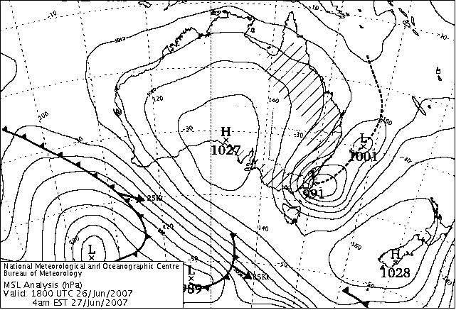
Storm to gale force winds battered VIC today while an extreme rainfall and flooding event unfolded in Gippsland. A huge pressure difference developed across the state this morning as the westernmost East Coast Low shown on the surface charts below pushed westwards into a high over SA. At 4am, the pressure in Adelaide was 1024hPa, 33hPa higher than the centre of the low close to Gabo Island. This pressure gradient forced a strong and moist airstream onto the Gippsland coast. It deluged southeast-facing valleys and mountainsides in West Gippsland with record rain, and brought flooding across all Gippsland and damaging winds to eastern and central parts of the state.

Rainfall

Heavy rain began falling in East Gippsland mid-evening yesterday, and spread to West Gippsland around daybreak today. The 24-hour to 9am rainfall totals (see wettest) showed that most of East Gippsland had received between 50 and 90mm, with some intense falls spreading from the east (see downpours). Mallacoota recorded 66mm between 9pm and 3am and Mt Nowa Nowa 55mm between midnight and 6am. Gabo Island Lighthouse recorded 90.2mm for the 24 hours, its heaviest one-day June total in 140 years. 58mm of that fell in 6 hours to 3am. Event totals for East Gippsland, spread over the 48 hours to 9am Thursday, were remarkably consistent, almost all between 80 and 120mm.

In West Gippsland, heavy rain began around dawn and fell continuously for 24 hours or more, with the majority of the rain being recorded in the 24 hours to 9am Thursday. The maps at right show that very heavy rainfall occurred in the Thomson, Macalister and Avon catchments to the north and NW of Sale, while a small area south of Traralgon also recorded high totals. Records were set at a number of locations. Woods Point's 101.0mm was its highest June one-day fall in 114 years, while Erica's 138.2 was an all time high in 47 years.

Some rainfall was phenomenal. The automatic flood warning raingauge on Mt Wellington, 70km NNW of Sale on the watershed of the Avon and Mitchell catchments, reported 318.6mm for the 24 hours to 9am Thursday, a new Victorian record for June (the all-time record for VIC is 375.0mm at Tanybryn in the Otway Ranges on 22 March 1983). A break-down of this total into the eight 3-hourly periods 9am to 9am shows how unrelenting the rain was: 61 65 43 33 33 28 32 23mm.

Even more phenomenal were the reports coming from the automatic weather station on Mt Baw Baw, which lies between the Thomson and Latrobe river catchments. Between 9am and 4.30pm it reported that 355.6mm had fallen causing concern that it was giving false data that may be misleading in an emergency situation. The figures were extraordinary, but internally consistent and temperature, wind and other elements being reported by the AWS appeared reasonable. With no nearby gauges or other means of immediately verifying the data, however, the Bureau suspended public reports from the AWS at 4.30pm pending further investigation. What reports were issued are summarised in downpours.

Heavy rainfall at official Bureau gauges for the 24 hours to 9am Thursday are shown in tomorrow's wettest section. Some of the highest gaugings for the 48 hours to 9am Thursday were:

  • Traralgon Creek catchment: Balook 164, Mt Hooghly 169, Mt Tassie 199, Koornalla 220 and Calignee North 184mm
  • Thomson-Macalister watershed: Murderers Hill 222, Mt Useful 142
  • Thomson catchment: Erica 149
  • Avon catchment: Mt Moornappa 195, Briagolong 143.
  • Avon-Mitchell watershed: Mt Wellington 334 (+ 17 following 9am Thursday), Reeves Knob 270 (+15)

Wind

Gale force winds swept many parts of the state throughout today and well into Thursday, with some gusts reaching hurricane force. Damage, mostly to trees and power supply lines, was widespread.

  • A man was killed when a 30m tree was blown onto his home at Mt Macedon late this evening, nearly cutting it in two.
  • Extensive damage to trees and powerlines occurred in central Victoria, with damage reported from Woodend, Gisborne, Macedon, Mount Macedon, Lancefield, Romsey, Tylden and Rushworth. Many roads were blocked by tree debris.
  • About 15,000 properties were without power after powerlines were blown down or brought down by falling trees and branches. Worst hit areas were Bairnsdale, Lakes Entrance, Sale, Maffra, Kinglake, Lilydale, Belgrave, and the Kyneton-Woodend area.
  • A man was injured when a tree fell on his stationary car while he was waiting for other trees to be cleared on the Princes Highway at Munro, NE of Stratford.
  • Fallen trees closed the Mt Dandenong Tourist Road for several hours.
  • Trees blown onto the track forced cancellation of Melbourne to Bairnsdale train services and their replacement by buses.

Highest reported gusts were in Alpine areas (Mt Hotham 137, Mt Buller 120, Falls Creek 115km/h). Some unusually high gusts were recorded in less exposed locations, however, including Kilmore Gap 111, Bairnsdale 96, Eildon Fire Tower 94, Dunns Hill (near Mt Dandenong) 93 and Mangalore Airport 91 (a new June record). Some 24-hour average windspeeds to 9am Thursday set new records - Mildura, Tatura and East Sale all had their windiest June days on record, while in the North Central district, Kilmore gap averaged 55.2km/h and Redesdale 44.1km/h over the full 24 hours. The Windiest and highest gusts sections below and for Thursday show the highest 24-hour average speeds and the highest gusts recorded.

Flooding

The torrential rain this morning caused rapid rises in the Thomson, Macalister, Avon and Mitchell Rivers. Runoff entered the streams more rapidly than usual because large areas of the catchments have not yet regained a covering of vegetation following last summer's devastating bushfires -- a good vegetation cover slows down water as it makes its way into streams. At 9 this morning, all rivers were below minor flood level. The map opposite for 11pm this evening shows that in just over 12 hours the Macalister, Avon and Mitchell Rivers had risen to major flood levels, and the Thomson to moderate level.

  • Swifts Creek on the Omeo Highway south of Omeo was cut off this morning when the Tambo River rose dramatically.
  • Licola on the Macalister was similarly isolated.
  • The Princes Highway was cut by the flooded Nicholson River at Nicholson, east of Bairnsdale.
  • Roads cut by floodwater included the main Bengworden and Marlo Roads.
  • SES personnel were sandbagging and doorknocking to alert residents to major flooding in Stratford and Bairnsdale, and at Boisdale on the Avon River.
  • A number of schools through Gippsland were closed due to lack of electricity or inaccessibility due to flooding.

Flood warnings were in place this evening for: major flooding in the Avon, Macalister upstream of Lake Glenmaggie, Thomson and Traralgon Creek at Traralgon; moderate flooding in the Latrobe, Snowy, Buchan, Tambo and Nicholson Rivers, and the Canna and Genoa Catchments.

NSW: Cold and windy with widespread snow

A pair of East Coast Lows menaced the NSW coast today. They can be seen on the surface charts below, slowly dumbbelling around one another under the rotational influence of an upper low that intensified over eastern NSW during the day. The upper low also dragged colder air northwards to progressively cover most of NSW as the day progressed. The surface low that moved to the South Coast overnight moved across the coast into the Southern Tablelands during the morning, then shifted northwards into the Central Tablelands later in the day as it weakened and became absorbed by the dominant Tasman sea low. By late this evening, this second low had deepened to 993hPa and was approaching the far South Coast.

The heaviest rain fell in the Bega Valley yesterday and up to the early hours of this morning, with top falls around 70 to 80mm (see wettest). Streams ran high, with water just under the Princes Highway bridge over the Pambula River, but no flooding was reported at minor levels or above.

Strong winds were reported, with ample evidence of gale to storm force winds in mountainous areas coming from widespread reports of large tree damage. However, the only significant strong wind gust reported in NSW was 115km/h at Green Cape on the far South Coast. A house at Tura Beach, just north of Merimbula and 50km north of Green Cape, was damaged by a tree blown onto it. There were also reports of many trees down on the far South Coast.

As the first low approached the coastline this morning, moisture wrapping around its southern flank moved into the cold airmass over the Southern Tablelands, producing widespread snow around Cooma. The animation in yesterday's report showed this moisture stream moving westwards underneath the low, then swinging northwards, bringing substantial snow to the Central Tablelands during the day and then lighter snow to the Northern Tablelands overnight into Thursday. Here is a summary of snow reports for the event:

  • Snowy Mountains: Resorts reported up to 40cm new snow yesterday and today.
  • Cooma - Monaro: Snow around Cooma was widespread and particularly heavy around Nimmitabel and Berridale. The Snowy Mountains Highway was closed between Cooma and Brown Mountain and between Cooma and Adaminaby. Roads northeast of Cooma were also closed by snow as was the Monaro Highway between Nimmitabel and Bombala. Country Energy reported major blackout problems around Berridale, Adaminaby, Bombala and Dalgety with all available staff trying to restore power, but experiencing access difficulties in the snow.
  • Canberra: Extensive snow settling to the 1000m level was reported on the ranges west of Canberra at 9am. Captains Flat SES reported heavy overnight snow settling in their area and across to Bungendore.
  • Batlow - Tumbarumba: Heavy overnight snow fell in the Bago State Forest south of Batlow, with around 5 to 10cm cover at the 1050m level.
  • Orange-Blayney: Snow began falling around Orange about 8am, when a 4-car accident closed an icy Mitchell Highway at Lucknow, just east of Orange. By midday, snow was reported settling from Orange to Blayney and to the northeast of Orange. The Mt Canobolas road was closed around 2pm.
  • Oberon Plateau - Crookwell - Taralga: Snow began falling around Oberon, Crookwell and Taralga about 8am. Higher country around Taralga had a 4cm cover mid-morning, while there was a 10-15cm cover in the high country (1100 to 1200m elevation) to the north around Gurnang. Snow began to settle around midday in Oberon, resulting in schools closing so that students from outlying properties could get home before roads closed. Moderate to heavy snow was falling from Hampton to Oberon mid afternoon, with snow 3cm deep in Oberon at 3.30pm. Snow 15cm deep was reported at Black Springs, 20km SW of Oberon, at 4pm. At 7pm, snow was 6cm deep in Oberon township, with flakes "the size of 50 cent pieces" falling. At the same time, there was a report of people being "snowed in" at Hampton. At 8pm, a farm out of Oberon reported 10cm covering paddocks. On Thursday, powder snow was reported falling south of Oberon along Mozart Road for about four hours around midday.
  • Lithgow - Bathurst: Snow began falling along the Great Western Highway from Yetholme to Mt Lambie before midday, and soon afterwards was reported falling in Portland and Sunny Corner. A few centimetres had settled down to the 1050m level around Yetholme by mid afternoon, and the Highway was closed between Mt Lambie and Yetholme at 3.45pm and between Mt Lambie and Bathurst Airport at 6.45pm. It reopened about 4.30am Thursday. Snow flurries were reported in Lithgow late afternoon.
  • Blue Mountains: Light snow showers were reported mid afternoon in the upper Blue Mountains at Mt Victoria, Blackheath, Medlow Bath and Katoomba, but did not settle. About an hour's heavier snow at Mt Victoria, from 4 to 5pm, also did not settle. At 9.30pm, snow was reported settling at Clarence, about 5km east of Lithgow.
  • Coonabarabran: Snow fell during the afternoon and early evening at Siding Springs Observatory, 20km west of Coonabarabran at an elevation of 1120m in the Warrumbungles but did not settle.
  • Northern Tablelands: Snow fell during the early morning hours of Thursday, with 4cm reported by the Guyra observer at 9am. Bureau observers at Glen Innes and Woolbrook also reported snow, but did not say if it accumulated on the ground. Travel advisories were in effect for the New England Highway at Ben Lomond Range north of Guyra and between Guyra and Armidale. Thunderbolts Way was closed between Gloucester and Nowendoc where it rises to about 950m. Snow 2-3cm deep was observed around midday Thursday on the Ben Lomond Range, with snow falling for over an hour soon after.

Lord Howe Island: Windy and wet

The easternmost East Coast Low on the surface charts below bullied Lord Howe Island overnight, giving the airport anemometer a workout that saw a new record daily wind run for June. 1398km of air passed the anemometer cups in the 24 hours to 9am, an average speed of 58.3km/h. 57mm was recorded in the raingauge between midnight and 9am as the low approached the island then headed for the NSW South Coast.


Records set or equalled today

These records are based on data received as at 0647 EST on 21/08/2008. Help in interpreting these statistics and information on quality control is here.

District Site Today Previous monthly record Previous all time record
if equalled or broken
Comments
Reading Reading Date Years Reading Date Years
Highest daily rainfall

NSW

South Coast

069137

GREEN CAPE AWS

65.2

29.2

02/06/2006

14

1 n

NSW

SW Slopes S

072163

TOOMA (EUDLO)

30.2

25.4

13/06/2001

11

1 y

VIC

E Gippsland

084016

GABO ISLAND LIGHTHOUSE

90.2

88.9

16/06/1952

140

1 y

VIC

E Gippsland

084142

GELANTIPY

51.6

44.0

23/06/1998

14

1 n

VIC

E Gippsland

084144

MT NOWA NOWA

78.2

63.6

20/06/2007

12

1 n Previous record set earlier this month.

Lowest maximum temperature

QLD

N Coast--Barron

031192

GREEN ISLAND

19.0

20.0

21/06/2007

12

1 P Previous record set earlier this month.

NSW

CW Plains S

050137

CONDOBOLIN AIRPORT AWS

8.9

8.9

21/06/2007

13

1 Y Equal to record. Previous record set earlier this month.

NSW

Sydney--west

067105

RICHMOND RAAF

11.5

11.8

17/06/1995

13

1 Y

Highest wind gust (km/h)

VIC

N Central

088109

MANGALORE AIRPORT

91

85.0

14/06/2004

16

Y

Highest daily average wind speed - anemometer above 3m (km/h)

ISL

Islands

200839

LORD HOWE ISLAND AERO

58.3

57.3

15/06/1999

13

1 Y


The day in charts
Surface charts Satellite images Rain & temperatures
4am EST Rainfall -- 24 hours to 9am
Available about 6am EST Available about 4am EST Available about 2pm EST
Week to 9am | SE AUS detail
10am EST Minimum temperature +/- normal
Available about noon EST Available about 10am EST Available about 2pm EST next day
Actual temperatures
4pm EST Maximum temperature +/- normal
Available about 6pm EST Available about 4pm EST Available about 2pm EST next day
Actual temperatures
10pm EST Solar Radiation
Available about midnight EST Available about 10pm EST Available about 2am EST next day

Summary of observations

For notes on how to interpret the data and quality control issues, see Daily Weather Summary Help.
**S** and **W** precede data flagged by the Bureau as suspicious or wrong
Data is as received at 00:50EST, 15/05/2012.

Major centres
Max
° C
+/- norm
° C
Min
° C
+/- norm
° C
Grass Min
° C
Rain to 9am mm Evaporation to 9am mm Sunshine hours Wind Run to 9am km (24-hour average km/h) Maximum Gust km/h / hour of occurrence
GERALDTON AIRPORT 22.9 +2.0 12.7 +1.7 12.3 0.0 7.0 -- 509 (21.2) 71/21
PERTH AIRPORT 21.9 +3.0 11.1 +2.1 6.0 0.0 3.6 3.5 449 (18.7) 41/19
ALBANY AIRPORT 22.0 +5.4 10.2 +2.1 5.2 0.0 4.8 0.2 527 (22.0) 71/17
BUNBURY 19.8 +1.4 12.8 +4.7 -- 2.6 -- -- 397 (16.5) 70/17
MANDURAH 18.9 -- 14.1 -- -- 0.0 -- -- 568 (23.7) 85/20
DARWIN AIRPORT 27.3 -3.3 18.0 -1.9 17.2 0.0 9.0 9.3 547 (22.8) 52/09
ALICE SPRINGS AIRPORT 17.1 -2.7 1.3 -3.8 -2.3 0.0 3.8 10.4 201 ( 8.4) 37/13
WHYALLA AERO 15.8 -1.5 6.5 +0.4 -- 0.2 0.6 -- 227 ( 9.5) 46/15
ADELAIDE (KENT TOWN) 15.3 -0.8 4.0 -4.1 -- 0.0 0.2 6.5 112 ( 4.7) 35/16
MOUNT GAMBIER AERO 13.6 -0.2 6.6 +0.8 3.3 2.2 0.0 4.1 339 (14.1) 52/11
MOUNT ISA AERO 18.0 -6.9 4.7 -5.3 3.3 0.0 3.8 10.5 354 (14.8) 43/10
CAIRNS AERO 21.0 -5.0 17.9 +0.1 17.0 0.0 3.8 0.5 367 (15.3) 41/08
TOWNSVILLE AERO 21.5 -4.1 15.0 +0.4 13.6 0.0 3.0 6.8 532 (22.2) 48/03
MACKAY M.O 18.1 -3.8 12.7 -1.3 -- 4.8 -- 7.1 300 (12.5) 39/10
ROCKHAMPTON AERO 18.8 -4.7 12.5 +1.6 11.2 13.8 0.8 -- 208 ( 8.7) 45/23
BUNDABERG AERO 18.7 -3.9 11.9 +0.3 -- 13.8 0.8 -- 322 (13.4) 46/12
NAMBOUR DPI 18.3 -3.3 9.9 +0.6 -- 18.0 10.0 -- 87 ( 3.6) 46/11
COOLANGATTA 19.1 -2.0 5.6 -5.9 -- 16.0 -- -- 81 ( 3.4) 43/15
BRISBANE AERO 17.3 -4.0 10.3 -0.2 7.0 14.6 2.4 9.9 367 (15.3) 68/12
TOOWOOMBA AIRPORT 11.7 -5.3 4.5 -3.0 -- 6.2 -- -- 512 (21.3) 61/12
GUNNEDAH RESOURCE CENTRE 10.7 -6.1 5.2 -0.9 1.1 0.2 0.4 -- 219 ( 9.1) --
COFFS HARBOUR MO 17.4 -2.0 4.4 -4.7 1.9 2.6 1.0 9.7 192 ( 8.0) 43/13
PORT MACQUARIE AIRPORT AWS 17.2 -2.3 3.6 -4.4 -- 2.0 -- -- -- --
WILLIAMTOWN RAAF 14.8 -2.8 8.9 +1.0 4.9 2.2 3.8 6.2 586 (24.4) 81/10
GOSFORD (NARARA RESEARCH STATION) AWS 14.3 -3.6 5.3 -1.2 -- 9.6 -- -- 64 ( 2.7) 43/11
ORANGE AGRICULTURAL INSTITUTE 10.4 -0.1 1.8 -0.8 2.0 5.0 0.0 0.0 -- --
DUBBO AIRPORT AWS 10.0 -6.4 4.6 0.0 -- 1.0 -- -- -- --
SYDNEY AIRPORT AMO 14.8 -2.8 7.9 -0.6 5.2 9.6 2.2 4.7 481 (20.0) 52/11
RICHMOND RAAF 11.5 -6.5 6.4 +1.5 -- 0.0 -- -- 180 ( 7.5) 46/14
BELLAMBI AWS 13.1 -4.6 10.0 -1.0 -- 14.2 -- -- 471 (19.6) 72/09
CANBERRA AIRPORT 7.7 -4.5 3.9 +2.9 3.5 25.2 2.8 0.0 325 (13.5) 41/06
WAGGA WAGGA AMO 12.1 -1.7 5.4 +1.7 2.0 5.8 2.2 1.6 365 (15.2) 52/09
ALBURY AIRPORT AWS 12.9 -1.3 5.0 +1.1 -- 0.0 -- -- 204 ( 8.5) 46/10
MILDURA AIRPORT 14.5 -1.5 3.7 -1.5 2.7 0.0 1.4 9.5 -- 59/14
TATURA INST SUSTAINABLE AG 13.6 -0.4 2.0 -1.7 -- 0.0 0.6 -- 437 (18.2) 80/12
BENDIGO AIRPORT 12.2 -1.0 5.5 +1.9 -- 0.0 -- -- 401 (16.7) 65/12
MELBOURNE REGIONAL OFFICE 13.2 -0.8 8.4 +1.5 6.1 7.4 0.6 -- 119 ( 5.0) 21/03
GEELONG AIRPORT 13.5 -1.1 7.0 +0.7 -- 5.2 -- -- 513 (21.4) 74/11
BALLARAT AERODROME 9.1 -1.7 4.1 +0.1 -- 2.8 -- -- 495 (20.6) 72/13
LAUNCESTON (TI TREE BEND) 12.3 -0.8 2.1 -0.8 -- 0.4 -- -- 216 ( 9.0) 50/14
HOBART AIRPORT 12.2 -0.7 3.5 -1.1 1.5 0.0 0.4 0.9 191 ( 8.0) 34/13
Max
° C
+/- norm
° C
Min
° C
+/- norm
° C
Grass Min
° C
Rain to 9am mm Evaporation to 9am mm Sunshine hours Wind Run to 9am km Maximum Gust km/h / hour of occurrence
Hottest
Highest maximum temperature>Greatest variation above normal maximum Highest minimum temperatureGreatest variation above normal minimum

28.3 COCOS ISLAND AIRPORT Islands ISL
28.1 WEST ROEBUCK W Kimberley WA
28.0 SCHERGER RAAF N Peninsula QLD
28.0 KURI BAY N Kimberley WA
28.0 BIDYADANGA W Kimberley WA

+6.3 : 23.5 HYDEN Cent Wheatbelt WA
+6.1 : 22.6 ALBANY Lower West WA
+5.9 : 21.8 ONGERUP Cent Wheatbelt WA
+5.6 : 21.1 ROCKY GULLY Lower West WA
+5.6 : 22.8 MERREDIN Cent Wheatbelt WA
+5.6 : 22.0 CORRIGIN Cent Wheatbelt WA

25.0 NORTHERN ENDEAVOUR Islands ISL
24.2 COCONUT ISLAND N Peninsula QLD
23.5 CHRISTMAS ISLAND AERO Islands ISL
23.1 COCOS ISLAND AIRPORT Islands ISL
22.6 HORN ISLAND N Peninsula QLD

+7.1 : 14.7 BUSSELTON AERO Lower West WA
+6.4 : 15.3 BUSSELTON Lower West WA
+6.1 : 11.5 JARRAHWOOD Lower West WA
+5.8 : 14.6 WITCHCLIFFE Lower West WA
+5.2 : 12.8 GOOMALLING Cent Wheatbelt WA

Coldest
Lowest maximum temperatureGreatest variation below normal maximum Lowest minimum temperatureGreatest variation below normal minimum

0.2 THREDBO AWS Snowy Mtns NSW
0.8 MT HOTHAM Upper NE VIC
1.6 FALLS CREEK Upper NE VIC
1.6 CHARLOTTE PASS (KOSCIUSKO CHALET) Snowy Mtns NSW

-8.4 : 6.7 MUDGEE AIRPORT AWS C Tablelands N NSW
-8.3 : 7.2 GULGONG POST OFFICE C Tablelands N NSW
-7.8 : 5.8 ARMIDALE (TREE GROUP NURSERY) N Tablelands W NSW
-7.8 : 3.2 ORANGE AIRPORT AWS C Tablelands S NSW
-7.8 : 8.5 PEAK HILL POST OFFICE CW Plains S NSW

-4.5 LAKE ST CLAIR NATIONAL PARK Central Plateau TAS
-4.2 MT HOTHAM Upper NE VIC
-4.1 THREDBO AWS Snowy Mtns NSW
-3.6 FALLS CREEK Upper NE VIC
-3.4 TARRALEAH VILLAGE Derwent Valley TAS

-9.9 : -3.0 EYRE Eucla WA
-7.9 : -1.6 WARBURTON AIRFIELD Interior WA
-7.2 : -1.0 ROSEDALE (TURRETFIELD RESEARCH CENTRE) Adelaide/Lofty SA
-6.6 : -0.1 NEWMAN AERO E Gascoyne WA

Wettest
Sunniest & dullest
Windiest
Highest gusts
Todays highest rainfall totals for the 24 hours to 9am. It includes the top 5 totals nationally followed by all reported falls of 50mm or more.
Highest and lowest recordings of hours of sunshine for the 24 hours to midnight.
Highest wind run totals in kilometres for the 24 hours to 9am (average speed in brackets). All reported runs > =25km/h are shown.
Highest wind gusts in km/h for the 24 hours to midnight followed by the hour in which it occurred. All stations with gusts > 89km/h are shown.
105.0 ERICA (PHILIPS BRIDGE) W Gippsland VIC
90.2 GABO ISLAND LIGHTHOUSE E Gippsland VIC
87.2 WANGARABELL E Gippsland VIC
86.8 MALLACOOTA E Gippsland VIC
86.8 METUNG (SUNNYBANK) E Gippsland VIC

NEW SOUTH WALES
South Coast
86.6 BROGO (HAWKS HEAD ROAD)
84.4 WYNDHAM POST OFFICE
83.2 GREEN CAPE LIGHTHOUSE
82.0 TUROSS
81.2 CATHCART (MOUNT DARRAGH)
79.2 BEGA AWS
78.0 MERIMBULA AIRPORT AWS
76.8 EDEN (CARAVAN PARK)
75.0 TATHRA (PANORAMA DRIVE)
72.6 WYNDHAM (NYUMBANI)
72.0 WAPENGO (HUNTERS RD)
71.2 BEMBOKA (THE KNOB)
71.0 QUAAMA (MERRYDALE)
69.2 EDEN (TIMBILLICA)
68.8 PAMBULA POST OFFICE
67.0 BROGO DAM
65.2 GREEN CAPE AWS
65.2 CATHCART (MOUNT DARRAGH TM)
65.0 COBARGO POST OFFICE
64.6 TURA BEACH (JAMES COOK COURT)
64.2 WAPENGO LAKE ROAD
63.0 BERMAGUI SOUTH (YOUNG STREET)
62.6 BROGO BRIDGE HOUSE
60.4 TOWAMBA (TOWAMBA ST)
60.0 CANDELO POST OFFICE
59.2 CANDELO (KANOONA (TILLSIDE))
52.4 KAMERUKA (KAMERUKA ESTATE)
52.0 BEMBOKA POST OFFICE
52.0 COUNTEGANY (GAERLOCH)
51.8 VERONA (COBBOBRA)
Goulburn/Monaro
69.4 BUKALONG STATION
68.4 CATHCART (OLD POST OFFICE)
60.0 NUMERALLA (GLOCCA MORRA)

VICTORIA
E Gippsland
90.2 GABO ISLAND LIGHTHOUSE
87.2 WANGARABELL
86.8 MALLACOOTA
86.8 METUNG (SUNNYBANK)
78.8 WEERAGUA (CANN RIVER (EAST BRANCH) AT CH
78.2 MT NOWA NOWA
78.0 CABBAGE TREE CREEK
76.2 NOWA NOWA
74.2 NICHOLSON WINERY
73.2 CANN RIVER (POST OFFICE)
70.0 SARSFIELD EAST
69.2 CLUB TERRACE
66.6 GENOA (FOOLS HAVEN)
64.6 ORBOST (COMPARISON)
63.7 BRUTHEN (POST OFFICE)
63.0 LAKE TYERS
60.8 BAIRNSDALE (MITCHELL RIVER @ ROSEHILL)
60.4 BETE BOLONG (RUSSELLS ESTATE)
60.0 POINT HICKS (LIGHTHOUSE)
60.0 GOONGERAH
58.8 ORBOST
56.4 BUCHAN (SNOWY RIVER AT D/S BASIN CREEK)
55.0 BUCHAN
55.0 ENSAY
54.4 BUTCHERS RIDGE
54.4 NICHOLSON (YENDALOCK)
54.0 LAKES ENTRANCE (EASTERN BEACH ROAD)
52.0 TUBBUT
51.6 GELANTIPY
51.0 DARGO
W Gippsland
105.0 ERICA (PHILIPS BRIDGE)
80.0 PAYNESVILLE
76.0 WALHALLA
72.0 MT MOORNAPA
61.0 REEVES KNOB
58.4 BAIRNSDALE AIRPORT
51.6 MITCHELL RIVER @ GLENALADALE

ISLANDS
Islands
77.0 LORD HOWE ISLAND (ORLANDO)

10.7 BROOME AIRPORT W Kimberley WA
10.6 RABBIT FLAT N Plateau NT
10.5 GILES METEOROLOGICAL OFFICE Interior WA
10.5 MOUNT ISA AERO Gulf Country QLD
10.4 ALICE SPRINGS AIRPORT N Plateau NT

.....

0.0 ORANGE AGRICULTURAL INSTITUTE C Tablelands S NSW
0.0 WELLINGTON (AGROWPLOW) CW Slopes S NSW
0.0 CANBERRA AIRPORT Goulburn/Monaro NSW
0.0 EAST SALE AIRPORT W Gippsland VIC
0.0 MELBOURNE AIRPORT E Central VIC
0.0 LAKE EILDON N Central VIC
0.0 SCOTTSDALE (WEST MINSTONE ROAD) N Coast TAS
0.0 BICHENO (COUNCIL DEPOT) E Coast TAS
0.0 LAKE LEAKE (ELIZABETH RIVER) E Coast TAS
0.0 LIAWENEE Central Plateau TAS
0.0 NORFOLK ISLAND AERO Islands ISL
0.0 COWRA RESEARCH CENTRE (EVANS ST) C Tablelands S NSW

1398 (58.3) LORD HOWE ISLAND AERO Islands ISL
1186 (49.4) FALLS CREEK Upper NE VIC
1134 (47.3) MONTAGUE ISLAND LIGHTHOUSE South Coast NSW
1030 (42.9) WILLIS ISLAND Islands ISL
976 (40.7) GREEN CAPE AWS South Coast NSW
943 (39.3) VARANUS ISLAND Islands ISL
891 (37.1) CAPE FLATTERY N Coast--Barron QLD
868 (36.2) MOUNT BULLER Upper NE VIC
830 (34.6) HOGAN ISLAND Islands ISL
829 (34.5) CAPE NATURALISTE Lower West WA
809 (33.7) ROTTNEST ISLAND Lower West WA
789 (32.9) BARROW ISLAND AIRPORT W Pilbara WA
756 (31.5) MCCLUER ISLAND N Rivers NT
756 (31.5) CAPE OTWAY LIGHTHOUSE W Coast VIC
750 (31.3) THREDBO AWS Snowy Mtns NSW
749 (31.2) EDDYSTONE POINT E Coast TAS
719 (30.0) AIREYS INLET W Coast VIC
712 (29.7) NORTH ISLAND Central West WA
708 (29.5) CAPE LEEUWIN Lower West WA
708 (29.5) GOULBURN AIRPORT AWS Goulburn/Monaro NSW
672 (28.0) COLAC (MT GELLIBRAND) W Coast VIC
670 (27.9) COCONUT ISLAND N Peninsula QLD
667 (27.8) MOUNT WELLINGTON Southeast TAS
652 (27.2) NEWCASTLE NOBBYS SIGNAL STATION AWS Hunter Valley NSW
641 (26.7) COOMA AIRPORT AWS Goulburn/Monaro NSW
635 (26.5) MOUNT BOYCE AWS C Tablelands S NSW
635 (26.5) WILSONS PROMONTORY LIGHTHOUSE W Gippsland VIC
634 (26.4) KILMORE GAP N Central VIC
631 (26.3) MOSS VALE AWS Illawarra NSW
626 (26.1) KING ISLAND AIRPORT King Island TAS
617 (25.7) PORT FAIRY AWS W Coast VIC
614 (25.6) GOVE AIRPORT N Rivers NT
606 (25.3) MT HOTHAM Upper NE VIC
600 (25.0) CENTRAL ARNHEM PLATEAU N Rivers NT
120/12 MOUNT BULLER Upper NE VIC
115/00 GREEN CAPE AWS South Coast NSW
115/07 FALLS CREEK Upper NE VIC
113/15 HOGAN ISLAND Islands ISL
111/17 KILMORE GAP N Central VIC
106/15 EAST SALE AIRPORT W Gippsland VIC
102/19 ROTTNEST ISLAND Lower West WA
98/07 LORD HOWE ISLAND AERO Islands ISL
96/08 BAIRNSDALE AIRPORT W Gippsland VIC
94/15 EILDON FIRE TOWER N Central VIC
93/16 WILSONS PROMONTORY LIGHTHOUSE W Gippsland VIC
93/17 DUNNS HILL E Central VIC
91/18 MANGALORE AIRPORT N Central VIC

Downpours High AWS wind reports
High rainfall for periods of 6 hours or less from AWS and synoptic reports. Storm force gusts (>89km/h) and 10-minute mean gales (>62km/h) reported by AWSs. Wind direction and mean windspeed are shown in brackets.

WESTERN AUSTRALIA
Lower West
BUSSELTON AERO
5.2mm in 31 min to 15:00 10.1mm/h
BRIDGETOWN
16.0mm in 3 hr to 18:00 5.3mm/h
10.4mm in 1 hr to 18:01 10.4mm/h
10.0mm in 1 hr to 19:01 10.0mm/h
15.0mm in 3 hr to 21:00 5.0mm/h
BUNBURY
7.8mm in 45 min to 17:54 10.4mm/h
20.0mm in 3 hr to 18:00 6.7mm/h
NEW SOUTH WALES
South Coast
GREEN CAPE AWS
39.0mm in 3 hr to 00:00 13.0mm/h
BEGA AWS
21.0mm in 3 hr to 00:00 7.0mm/h
MERIMBULA AIRPORT AWS
20.0mm in 3 hr to 00:00 6.7mm/h
11.6mm in 52 min to 01:52 13.4mm/h
18.0mm in 3 hr to 03:00 6.0mm/h
Goulburn/Monaro
BOMBALA AWS
15.0mm in 3 hr to 03:00 5.0mm/h
VICTORIA
Upper NE
MOUNT BULLER
18.0mm in 3 hr to 15:00 6.0mm/h
MT HOTHAM AIRPORT
18.0mm in 3 hr to 15:00 6.0mm/h
FALLS CREEK
10.0mm in 1 hr to 08:30 10.0mm/h
19.0mm in 3 hr to 09:00 6.3mm/h
10.8mm in 1 hr to 10:00 10.8mm/h
19.0mm in 3 hr to 12:00 6.3mm/h
E Gippsland
GABO ISLAND LIGHTHOUSE
58.0mm in 6 hr to 03:00 9.7mm/h
MALLACOOTA
10.0mm in 1 hr to 00:00 10.0mm/h
27.0mm in 3 hr to 00:00 9.0mm/h
11.8mm in 1 hr to 00:30 11.8mm/h
12.6mm in 1 hr to 01:30 12.6mm/h
11.4mm in 30 min to 02:00 22.8mm/h
19.2mm in 1 hr to 02:30 19.2mm/h
39.0mm in 3 hr to 03:00 13.0mm/h
GELANTIPY
20.0mm in 3 hr to 06:00 6.7mm/h
COMBIENBAR AWS
15.0mm in 3 hr to 03:00 5.0mm/h
MT NOWA NOWA
16.0mm in 3 hr to 03:00 5.3mm/h
11.2mm in 1 hr to 04:30 11.2mm/h
10.8mm in 1 hr to 05:00 10.8mm/h
10.8mm in 1 hr to 05:30 10.8mm/h
7.6mm in 20 min to 05:50 22.8mm/h
20.0mm in 1 hr to 06:00 20.0mm/h
39.0mm in 3 hr to 06:00 13.0mm/h
15.4mm in 1 hr to 06:30 15.4mm/h
ORBOST
10.6mm in 1 hr to 03:00 10.6mm/h
23.0mm in 3 hr to 03:00 7.7mm/h
15.0mm in 3 hr to 06:00 5.0mm/h
LAKES ENTRANCE (EASTERN BEACH ROAD)
34.0mm in 6 hr to 15:00 5.7mm/h
W Gippsland
EAST SALE AIRPORT
16.0mm in 3 hr to 09:00 5.3mm/h
NOOJEE (SLIVAR)
31.0mm in 6 hr to 15:00 5.2mm/h
BAIRNSDALE AIRPORT
12.0mm in 1 hr to 07:00 12.0mm/h
24.0mm in 3 hr to 09:00 8.0mm/h
18.0mm in 3 hr to 12:00 6.0mm/h
MT BAW BAW
Caution: See text of Victoria article above

19.0mm in 3 hr to 09:00 6.3mm/h
11.6mm in 30 min to 10:00 23.2mm/h
19.6mm in 1 hr to 10:00 19.6mm/h
19.6mm in 30 min to 10:30 39.2mm/h
31.2mm in 1 hr to 10:30 31.2mm/h
13.4mm in 18 min to 10:48 44.7mm/h
10.6mm in 12 min to 11:00 53.0mm/h
43.6mm in 1 hr to 11:00 43.6mm/h
24.8mm in 30 min to 11:30 49.6mm/h
48.8mm in 1 hr to 11:30 48.8mm/h
15.0mm in 18 min to 11:48 50.0mm/h
9.4mm in 12 min to 12:00 47.0mm/h
49.2mm in 1 hr to 12:00 49.2mm/h
112.0mm in 3 hr to 12:00 37.3mm/h
15.4mm in 19 min to 12:24 48.6mm/h
6.2mm in 7 min to 12:31 53.1mm/h
26.2mm in 29 min to 13:00 54.2mm/h
51.4mm in 1 hr to 13:00 51.4mm/h
27.0mm in 30 min to 13:30 54.0mm/h
7.2mm in 8 min to 13:38 54.0mm/h
21.0mm in 22 min to 14:00 57.3mm/h
55.2mm in 1 hr to 14:00 55.2mm/h
27.6mm in 29 min to 14:29 57.1mm/h
14.6mm in 17 min to 14:48 51.5mm/h
10.4mm in 12 min to 15:00 52.0mm/h
54.6mm in 1 hr to 15:00 54.6mm/h
26.0mm in 30 min to 15:30 52.0mm/h
25.8mm in 30 min to 16:00 51.6mm/h
51.8mm in 1 hr to 16:00 51.8mm/h
30.2mm in 30 min to 16:30 60.4mm/h
56.0mm in 1 hr to 16:30 56.0mm/h
MT MOORNAPA
10.4mm in 1 hr to 06:00 10.4mm/h
17.0mm in 3 hr to 06:00 5.7mm/h
13.0mm in 1 hr to 06:30 13.0mm/h
14.2mm in 1 hr to 07:00 14.2mm/h
14.8mm in 1 hr to 07:30 14.8mm/h
16.4mm in 1 hr to 08:00 16.4mm/h
19.0mm in 1 hr to 08:30 19.0mm/h
46.0mm in 3 hr to 09:00 15.3mm/h
11.8mm in 1 hr to 12:00 11.8mm/h
30.0mm in 3 hr to 12:00 10.0mm/h
12.4mm in 30 min to 12:30 24.8mm/h
22.2mm in 1 hr to 12:30 22.2mm/h
14.8mm in 1 hr to 13:00 14.8mm/h
31.0mm in 3 hr to 15:00 10.3mm/h
61.0mm in 6 hr to 15:00 10.2mm/h
E Central
DUNNS HILL
15.0mm in 3 hr to 15:00 5.0mm/h
TASMANIA
E Coast
EDDYSTONE POINT
5.2mm in 13 min to 17:44 24.0mm/h
ISLANDS
Islands
LORD HOWE ISLAND AERO
6.2mm in 9 min to 08:54 41.3mm/h
33.0mm in 3 hr to 09:30 11.0mm/h

WESTERN AUSTRALIA
Lower West
ROTTNEST ISLAND : 100(350/ 72 ) at 16:30
DWELLINGUP : 91(340/ 58 ) at 21:00
NEW SOUTH WALES
Hunter Valley
NEWCASTLE NOBBYS SIGNAL STATION AWS : 82(300/ 65 ) at 11:00
MURRURUNDI GAP AWS : 83(330/ 65 ) at 22:45
South Coast
MONTAGUE ISLAND LIGHTHOUSE : 91(240/ 76 ) at 00:00
GREEN CAPE AWS : 109(200/ 89 ) at 00:23
Riverina E
DENILIQUIN AIRPORT AWS : 80(230/ 63 ) at 17:00
VICTORIA
Wimmera S
GRAMPIANS (MOUNT WILLIAM) : 106(210/ 70 ) at 14:00
Upper NE
MOUNT BULLER : 119(170/ 74 ) at 14:00
FALLS CREEK : 115(200/ 67 ) at 07:13
W Gippsland
EAST SALE AIRPORT : 102(170/ 74 ) at 14:48
WILSONS PROMONTORY LIGHTHOUSE : 93(150/ 72 ) at 16:58
KINGFISH A SHIP LOG 206 : 135(150/108 ) at 13:50
BAIRNSDALE AIRPORT : 87(170/ 63 ) at 11:00
E Central
SOUTH CHANNEL ISLAND : 89(180/ 65 ) at 14:49
N Central
REDESDALE : 76(200/ 63 ) at 11:40
MANGALORE AIRPORT : 89(190/ 63 ) at 19:00
KILMORE GAP : 111(170/ 74 ) at 18:00
EILDON FIRE TOWER : 95(230/ 32 ) at 16:01
TASMANIA
E Coast
EDDYSTONE POINT : 78(180/ 63 ) at 04:00
ISLANDS
Islands
LORD HOWE ISLAND WINDY POINT : 109(100/ 83 ) at 08:46
HOGAN ISLAND : 113(140/ 91 ) at 15:30
LORD HOWE ISLAND AERO : 98( 90/ 72 ) at 08:00