 |
 The
surface chart for 2pm WST around the time the front crossed Perth. The
parent Low had deepened by 10hPa over the past 12 hours, but steadied
at around
980hPa for the next 24 hours as it tracked slowly east along the south
coast dragging a succession of troughs across the Southwest. The system
weakened late Monday before heading off to the SSE. BoM The
surface chart for 2pm WST around the time the front crossed Perth. The
parent Low had deepened by 10hPa over the past 12 hours, but steadied
at around
980hPa for the next 24 hours as it tracked slowly east along the south
coast dragging a succession of troughs across the Southwest. The system
weakened late Monday before heading off to the SSE. BoM  |
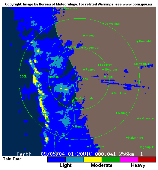 |
 Radar
returns at 9.20am WST show a 150km-wide rainband arriving on the Perth
coast but already well into the far SW. The heavy showers at the rear
of the band arrived in the metro area around noon and were accompanied
by squally winds gusting to 82km/h at Perth Airport and 104km/h at Ocean
Reef. BoM Radar
returns at 9.20am WST show a 150km-wide rainband arriving on the Perth
coast but already well into the far SW. The heavy showers at the rear
of the band arrived in the metro area around noon and were accompanied
by squally winds gusting to 82km/h at Perth Airport and 104km/h at Ocean
Reef. BoM |
 |
 The
rain map for the week ended Tuesday 11 May captures all the rain that
fell during this event. Most fell from the rainband that preceded the
first front. While there were good falls along most of the west coast,
the slow movement of the low before it moved off to the south kept winds
solidly from the west, robbing the Wheat Belt and South Coast east of
Albany of any worthwhile rain. BoM The
rain map for the week ended Tuesday 11 May captures all the rain that
fell during this event. Most fell from the rainband that preceded the
first front. While there were good falls along most of the west coast,
the slow movement of the low before it moved off to the south kept winds
solidly from the west, robbing the Wheat Belt and South Coast east of
Albany of any worthwhile rain. BoM |
 Strong
front brings rain and disruption to SW WA Strong
front brings rain and disruption to SW WA
A frontal system moved into southern WA today bringing welcome
rain, but also gales, power failures, local flooding, minor property damage
and traffic and shipping disruption.
The rain was heaviest in the Central West, Lower West and Southwest Coasts
since early July 2003 with many locations recording more in the 3 days to 11
May
than they
had in the preceding 7 months. In the hour to 1pm, Perth Airport registered
twice the rainfall recorded in the five months from December 2003 to April
2004. Among the highest falls for the week ended 11 May, all in the Lower
West and Southwest,
were:
108.0 DWELLINGUP
105.8 WELLINGTON MILL ALERT
100.8 JARRAHWOOD
100.2 WELLINGTON MILL
92.1 NANNUP
90.0 WITCHCLIFFE
82.0 FERGUSON VALLEY
79.4 FOREST GROVE
77.2 ROLEYSTONE
76.4 COWARAMUP
72.8 ACTON PARK
72.0 ASTON DOWNS TBRG
71.3 BOYANUP
70.4 PICKERING BROOK
69.0 BEDFORDALE
69.0 BUSSELTON
66.8 WANNEROO
65.2 KARNET
64.6 DARDANUP
63.2 JINDONG
63.0 BUSSELTON SHIRE
63.0 BUSSELTON AERO
63.0 HENTY BROOK
62.4 LEEMAN
61.2 BICKLEY
61.0 BRUNSWICK JUNCTION
60.6 KARRAGULLEN NORTH
60.6 PINJARRA
In the Central West, Eneabba topscored with 47.2mm.
Torrential rain fell just ahead of the front  giving
many places from just north of Perth to Busselton around 20mm in 1
hour and around 30mm in 3 hours (see Downpours below).
Busselton Airport recorded 24.6mm in the hour to 11am and Perth Airport
the same amount in the hour to 1pm. Flash flooding was reported in northwestern
suburbs of Perth. giving
many places from just north of Perth to Busselton around 20mm in 1
hour and around 30mm in 3 hours (see Downpours below).
Busselton Airport recorded 24.6mm in the hour to 11am and Perth Airport
the same amount in the hour to 1pm. Flash flooding was reported in northwestern
suburbs of Perth.
Gale force squally winds accompanied the front and moderated only slightly
behind it in the strong westerly stream. Ocean Reef, 25km NW of Perth CBD,
and Cape Leeuwin both reported peak gusts of 104km/h, while heavy seas and
wind gusting to 84km/h on Rottnest Island stopped most ferry services for the
day. Trees were blown onto a car in Perth and there were numerous weather-related
accidents. Powerlines were damaged from Geraldton to Albany cutting power
to about 6,000 homes.
Darlington,
20km
east
of Perth,
was worst affected with about 2,000 homes without power until late evening
or early Monday. The SES attended about 100 callouts in Perth and elsewhere,
mostly to deal with roof flooding caused by blocked gutterings and wind-damaged
roof
tiles. Minor damage was reported from tree branches blown onto a few houses
and sheds, and a house in Wonnerup, 8km ENE of Busselton, had part of its roof
blown onto an adjacent house.
The strong westerly component in the wind, which continued after the passage
of the front, meant that rain was confined to the Central and Southwest Coasts  .
But while the rain ran out of puff east of the Darling Range, the wind didn't
and widespread severe dust storms were reported from the Great Southern, the
Wheat Belt and the Central West. The observer at Ongerup reported less than
100m visibility at 3pm while at Lake Grace, 100km north, visibility was only
500m at both the noon and 3pm observations. A football match at Kukerin, 20km
west of Lake Grace, had to be abandonned when dust reduced visibility to a
few metres and players could no longer see the ball. WAFarmers president Trevor
De Landgrafft told the West Australian that dust storms had caused
some erosion where farmers had burnt stubble ready for cropping but rain had
not
been enough for seeding to begin. ABC Radio reported that early sown canola
and lupin crops were blown out of the ground, paddocks blown bare of topsoil
and fences toppled against the weight of built up debris and sand. .
But while the rain ran out of puff east of the Darling Range, the wind didn't
and widespread severe dust storms were reported from the Great Southern, the
Wheat Belt and the Central West. The observer at Ongerup reported less than
100m visibility at 3pm while at Lake Grace, 100km north, visibility was only
500m at both the noon and 3pm observations. A football match at Kukerin, 20km
west of Lake Grace, had to be abandonned when dust reduced visibility to a
few metres and players could no longer see the ball. WAFarmers president Trevor
De Landgrafft told the West Australian that dust storms had caused
some erosion where farmers had burnt stubble ready for cropping but rain had
not
been enough for seeding to begin. ABC Radio reported that early sown canola
and lupin crops were blown out of the ground, paddocks blown bare of topsoil
and fences toppled against the weight of built up debris and sand.
Maximum temperatures ahead of the front in SE WA were 9 to 12 above average
with Eyre, Balladonia and Esperance all topping 30°.
|