Quality
control note: Data is final. It includes late-received rainfall data and has been subject to BoM quality control checks.
Data is as received at 13:38EST, 03/03/2004. |
Weather observations for today
Noteworthy
Weather
Capital
Cities
Regional
Cities
Alpine
Stations
Bureau of Meteorology Rainfall Bulletins and Weather Notes
|
| Hottest |
| Highest maximum temperature> | Greatest variation above normal maximum |
Highest minimum temperature | Greatest variation above normal minimum |
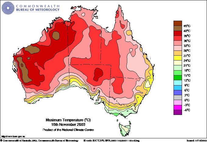
44.0 ROEBOURNE E Pilbara WA
44.0 GASCOYNE JUNCTION W Gascoyne WA
44.0 MORAWA Central West WA
43.6 FITZROY CROSSING AERO W Kimberley WA
43.5 ENEABBA Central West WA
|
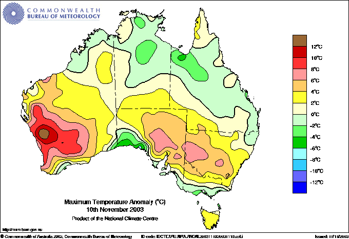
+14.0
43.5 ENEABBA Central West WA
+13.2
44.0 MORAWA Central West WA
+12.4
42.3 CARNAMAH Central West WA
+12.2
43.0 MULLEWA Central West WA
+10.9
42.3 PAYNES FIND E Gascoyne WA
|
28.7 WYNDHAM N Kimberley WA
27.8 ARGYLE AERODROME E Kimberley WA
27.6 TROUGHTON ISLAND N Kimberley WA
27.1 KURI BAY N Kimberley WA
27.0 WARRUWI N Rivers NT
27.0 WULUNGURRU N Plateau NT
|
+8.0
21.7 MORAWA Central West WA
+7.8
24.4 ROMA AIRPORT Maranoa QLD
+6.7
19.0 BADGINGARRA RESEARCH STN Lower West WA
+6.5
19.7 CARNAMAH Central West WA
+6.3
22.9 MARREE NE Pastoral SA
|
| Coldest |
| Lowest maximum temperature | Greatest variation below normal maximum |
Lowest minimum temperature | Greatest variation below normal minimum |
12.0 MOUNT READ W Coast TAS
12.5 MAATSUYKER ISLAND LIGHTHOUSE Southeast TAS
14.0 THREDBO AWS Snowy Mtns NSW
14.4 PARAWA (SECOND VALLEY FOREST AWS) Adelaide/Lofty SA
14.8 MT HOTHAM Upper NE VIC
|
-4.5
21.0 NULLARBOR W Agricultural SA
-4.3
21.5 CEDUNA AMO W Agricultural SA
-4.2
17.1 MOORABBIN AIRPORT E Central VIC
-4.1
19.7 EUCLA Eucla WA
-3.7
35.5 ELLIOTT N Plateau NT
-3.7
16.4 LAKES ENTRANCE E Gippsland VIC
|
0.2 LIAWENEE Central Plateau TAS
1.9 CHARLOTTE PASS (KOSCIUSKO CHALET) Snowy Mtns NSW
2.0 KEITH (MUNKORA) Mallee/Upper SE SA
2.0 PERISHER VALLEY SKI CENTRE Snowy Mtns NSW
2.4 MOUNT READ W Coast TAS
|
-6.4
2.9 NHILL Wimmera N VIC
-5.4
5.5 COROWA AIRPORT Riverina E NSW
-5.3
12.5 WILUNA Interior WA
-4.8
5.0 KEITH Mallee/Upper SE SA
-4.5
5.0 HORSHAM (POLKEMMET) Wimmera S VIC
-4.5
4.1 RUTHERGLEN RESEARCH Lower NE VIC
-4.5
3.0 BUSHY PARK (BUSHY PARK ESTATES) Derwent Valley TAS
-4.5
5.6 FLINDERS ISLAND AIRPORT Flinders Is/Bass St TAS
|
| Wettest |
Major City Extremes |
| Todays highest rainfall totals for the 24 hours to 9am.
It includes the top 5 totals nationally followed by all reported falls of 50mm or more. |
43.0 GURRUNDAH (ASHWELL) Goulburn/Monaro NSW
38.6 TWEED HEADS GOLF CLUB North Coast NSW
37.2 KATHERINE RURAL COLLEGE N Rivers NT
35.0 JULIUS DAM Gulf Country QLD
34.0 MARANBOY HILL N Rivers NT
|
|
| Max | +/- norm |
Min | +/- norm | Rain to 9am |
| BROOME AIRPORT |
32.0 |
-1.5 |
23.9 |
-1.1 |
0.0 |
| PERTH AIRPORT |
34.8 |
+9.2 |
16.3 |
+3.7 |
0.0 |
| ALBANY AIRPORT |
20.0 |
-0.8 |
12.7 |
+2.1 |
0.0 |
| KALGOORLIE-BOULDER AIRPORT |
37.2 |
+8.3 |
18.0 |
+4.0 |
0.0 |
| DARWIN AIRPORT |
35.0 |
+1.8 |
24.4 |
-0.9 |
0.2 |
| ALICE SPRINGS AIRPORT |
35.8 |
+2.2 |
18.6 |
+0.8 |
0.0 |
| ADELAIDE (KENT TOWN) |
29.6 |
+5.0 |
12.1 |
-1.7 |
0.0 |
| MOUNT GAMBIER AERO |
20.3 |
+0.2 |
6.4 |
-1.8 |
0.0 |
| CAIRNS AERO |
31.7 |
+1.1 |
22.6 |
+0.3 |
0.6 |
| TOWNSVILLE AERO |
30.6 |
-0.1 |
22.3 |
-0.5 |
1.2 |
| ROCKHAMPTON AERO |
29.5 |
-1.7 |
19.4 |
0.0 |
0.0 |
| AMBERLEY AMO |
28.0 |
-1.5 |
13.7 |
-2.6 |
0.0 |
| BRISBANE AERO |
25.7 |
|
16.6 |
|
5.0 |
| ARMIDALE AIRPORT AWS |
22.5 |
|
8.2 |
|
0.4 |
| COFFS HARBOUR MO |
25.0 |
+0.1 |
13.4 |
-2.6 |
0.0 |
| NEWCASTLE NOBBYS SIGNAL STATION AWS |
21.7 |
-1.9 |
17.2 |
+1.1 |
0.0 |
| SYDNEY (OBSERVATORY HILL) |
24.5 |
+0.9 |
16.6 |
+1.1 |
0.0 |
| PROSPECT DAM |
28.0 |
+2.9 |
13.5 |
-0.6 |
0.0 |
| WOLLONGONG UNIVERSITY |
23.9 |
+1.1 |
15.1 |
+0.7 |
0.0 |
| CANBERRA AIRPORT |
27.7 |
+5.2 |
9.2 |
+0.6 |
0.0 |
| WAGGA WAGGA AMO |
30.9 |
+5.5 |
7.5 |
-3.0 |
0.0 |
| MILDURA AIRPORT |
33.2 |
+6.0 |
11.9 |
-0.4 |
0.0 |
| EAST SALE AIRPORT |
21.0 |
0.0 |
12.3 |
+2.9 |
0.0 |
| MELBOURNE REGIONAL OFFICE |
20.0 |
-1.8 |
10.1 |
-1.0 |
0.0 |
| LAVERTON RAAF |
18.9 |
-2.4 |
5.6 |
-4.3 |
0.0 |
| BALLARAT AERODROME |
19.8 |
+0.4 |
6.5 |
-1.2 |
0.0 |
| LAUNCESTON AIRPORT |
21.8 |
+3.1 |
5.3 |
-1.8 |
0.0 |
| HOBART (ELLERSLIE ROAD) |
21.4 |
+2.8 |
8.4 |
-0.8 |
0.0 |
|
�