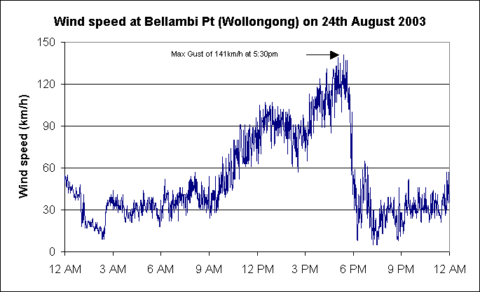
| Above: Wind speed at
Bellambi, north of Wollongong today. The wind was above gale force
(63km/h) nearly
continuously from 10.30am to 5.45pm. The
peak gust of 141km/h at 5.30pm was the second highest ever recorded
in NSW in August, the highest being 148km/h at nearby Wollongong University
in 1981. The highest wind gust ever recorded in mainland NSW is 174km/h
on
3rd December 2001 at Richmond during a thunderstorm. BoM |
 |

Above: The surface charts from
10am Saturday to 4am Monday show the cause of the widespread gales. A Low
of 996hPa near Adelaide moved steadily SE through southeastern SA, crossing
the coast east of Mt Gambier around midnight this morning with its central
pressure down to around 985hPa. It continued moving SE down the west Tasmanian
coast until 10am, when it was close to Strahan. It then became nearly stationery
near Maatsuyker Island off the TAS South Coast, and dropping to 973hPa
at 10pm before moving slowly off to the south. Note how the 1012 isobar
moves south over QLD and northern NSW today as the ridge over QLD strengthens,
further squeezing the gradient over NSW and VIC. BoM |
 |
The extent of the rainband is shown by
the Weatherzone combined
radar and lightning tracker images for NSW (above) and
VIC/TAS (below) a
little before midnight last night. Nearly continuous rain is falling in
an area
extending
from north of Moree to well offshore Newcastle, and southwest to western
VIC and central TAS.
|
 |
 |
Above: Bureau rainfall registrations for the 24 hours to 9 this
morning show that almost every station in the southeastern third of the
continent
received rain, much of it above 25mm. Heaviest concentrations were on the
NSW Northern Tablelands and Slopes, NE VIC and NE TAS, all exposed to the
strong northwesterly flow. BoM |
| Below: 3-hourly IR satellite
images from 3am 23rd to 3am 25th (midnight frames missing). At 3am
on the 23rd, scattered and mostly dry thunderstorms were lurking
in SW QLD and western NSW. Between 3am and 9am on the 23rd, the cloudmass
became
rapidly more organised. As a deck of high cloud drifts away over
the NSW coast,
the
main rainband spears in from the northwest late morning, reaching
the NSW and VIC coasts by 6pm. The area of heaviest rain lies under
the pure white
(coldest)
cloud
tops. From 6pm on the 23rd, the cloudband assumes the classic comma-shaped
signature as it wraps around the deepening low. Weatherzone, BoM. (GMS-5
backup with GOES-9 operated by the joint effort of JMA and US
NOAA NESDIS over the Western Pacific) |
 |
 Emergency
services received over 15,000 calls for assistance as
the strongest widespread winds for many years caused damage across
NSW, the ACT, VIC and TAS. Wind gusted to 141km/h at Bellambi north of
Wollongong, but of greater significance was the sheer number of locations
across three states reporting gusts or sustained windspeeds of 90km/h
or more, the level at which wind becomes damaging. See Gales
and Gusts for a full listing. Emergency
services received over 15,000 calls for assistance as
the strongest widespread winds for many years caused damage across
NSW, the ACT, VIC and TAS. Wind gusted to 141km/h at Bellambi north of
Wollongong, but of greater significance was the sheer number of locations
across three states reporting gusts or sustained windspeeds of 90km/h
or more, the level at which wind becomes damaging. See Gales
and Gusts for a full listing.
NSW was the worst affected. Twenty-seven local
government areas in NSW were subsequently declared natural disaster areas.
The Insurance Disaster Response Organisation indicated Tuesday that around
5,000 claims for damage would run to nearly $10m.
In NSW, gales developed in the southeast of the state
around 10am and arrived in Sydney around noon where they continued until
early evening. An SES spokesman said on ABC Radio that the worst affected
areas were "from
the Shoalhaven
and
Wollongong,
then along
the coast, Botany
Bay,
Sutherland's
been badly hit, Randwick, Waverly, Woolhara, up to Kuringai and around
the Newcastle areas." Over 14,000 calls for help were received across
the state as a result of wind damage, with emergency volunteers being
brought from country areas as far away as Broken Hill to help
with the cleanup.
Damage to trees and roofing was extensive and 190,000
homes were without
power
by the time the wind eased later in the evening. By Monday morning,
Integral Energy had identified 60,000 customers still without electricity
in the
Illawarra,
and Energy
Australia was working
to restore power to 10,000 more in Sydney and on the Central Coast. In
many areas, the power infrastructure was so badly damaged that it took
days to repair or replace. 38,000 homes were still without power on Tuesday
morning and 4,000 on Friday morning, 5 days after the event..
In Sydney, a man was killed in the northern
Sydney suburb of St Ives when a tree was blown onto his car. Several other
people
were hospitalised
because of injuries, including a Mosman man hit by a falling tree.
In addition to bringing down trees and powerlines onto
cars and homes, the
wind blew
a two-storey house onto a single storey one in Stanmore. The Eastern Suburbs
and Cronulla Railways were closed during the evening. A cruiser sank
and several yachts were damaged at the Cruising yacht Club in Sydney. Peak wind
gusts were 121km/h at Kurnell and North Head.
Thirty
schools were
closed by wind damage in Wollongong and on the South Coast, with
the new Kiama primary school losing its roof. Highest wind gusts in the region,
apart from the 141km/h at Bellambi, were 121 at Albion Park, 119 at Nowra RAN
and 115 at Moss Vale. Eurobodalla
Shire was completely blacked out during the evening when the area's two main
supply lines between
Nowra and Bega failed, with about 95% restored by late Monday morning.
Nowra's sewerage system was also damaged. The main Illawarra Railway
between Sutherland
and Nowra was closed
from mid-afternoon by electrical failures, wind-borne debris and a tree
across the tracks at Dunmore, between Wollongong and Kiama. Trees blown
onto the F6 north of Wollongong caused a 10km traffic tailback, while
The Kings Highway west of Batemans Bay and the Princes
Highway north
of Ulladulla
were closed for a time
by fallen trees and powerlines and
motor accidents. A Wollongong man received serious head injuries when
blown off his roof, and a woman was serioiusly injured by a falling shop
awning in Crown Street.
Elsewhere in NSW, tree and house damage were reported
from Orange, Bathurst, Portland and Lithgow in the Central West, and Wagga
and Albury in the south. A child suffered a fractured skull when a tree
was blown onto a garage in Bathurst. In the
Hunter,
12,000 homes lost power, and there were reports of yachts torn from moorings
in Port Stevens and roofs blown from houses. Wind gusted to 106km/h at Nobbys
in Newcastle. Damage was greatest along the coast from Lake Macquarie to Newcastle.
SES received
300 calls
to assist securing roofs and removing trees blocking roads. Over 9,000
homes on the Central Coast were blacked out and there were 150 SES call-outs.
In the ACT, wind gusted to 93km/h at Canberra Airport.
In addition to power blackouts, uprooted trees and houses losing roof
tiles, a house
in Lyneham was set on fire by fallen powerlines. Several houses in
northern Canberra lost their roofing. The local TV station was put out
of action for the evening.
In VIC, the greatest
wind damage was caused in Melbourne's southeast and the Mornington
Peninsula, with Frankston, Hastings and Sorrento worst hit. Winds reached 121km/h
on South Channel Island, a mudflat in Port Phillip Bay about 7km NE of Sorrento.
At Wilsons Promintory a maximum gust of 159km/h was recorded. The SES responded
to over 1,400 calls for help across the state. Two homes in Williamstown,
just
southwest
of Melbourne
CBD, received
extensive
damage from fallen
trees.
Extensive tree damage
was also reported in alpine areas of the state. Power was lost for
several hours in Wangaratta, Violet Town and Euroa when two large trees
were blown onto high tension lines. Blackouts in West Gippsland left 2,000
homes without power for the night.
In TAS,
boats in the D'Entrecasteaux Channel south of Hobart were damaged,
some at Kettering breaking their moorings.
Downed trees closed a number of roads around Burnie,
Smithton and Sheffield. On Flinders Island, wind which gusted to 109km/h
at the airport blew roofing from a supermarket onto the island's hospital,
taking out the communications
satellite dish. The island was also without power from 10pm until Monday
afternoon. There were lengthy power cuts on the Tasman Peninsula, South Arm
and Bruny Island,
with
wind gusts
to
126km/h
on
Tasman
Island.
Police issued warnings against using many roads in the state's southeast during
the day due
to wind
debris and
flash flooding. In Hobart, the barometer dropped to 976.3hPa at midday,
not far off its 966.9hPa record (in computerised data) set in 1955.
 A
major rainband moved SE across NSW, VIC and TAS overnight and today setting
new records for August in the three states. In an unusually
widespread one-day rain event, falls of 25 to 75mm were recorded the
length of the NSW slopes and ranges, and across most of northern, central
and western VIC, northern and eastern TAS and southeastern SA. It was
one
of the best rain events in three years in many areas and, following on
from earlier falls, has greatly improved the outlook for farming in the
three
states. A
major rainband moved SE across NSW, VIC and TAS overnight and today setting
new records for August in the three states. In an unusually
widespread one-day rain event, falls of 25 to 75mm were recorded the
length of the NSW slopes and ranges, and across most of northern, central
and western VIC, northern and eastern TAS and southeastern SA. It was
one
of the best rain events in three years in many areas and, following on
from earlier falls, has greatly improved the outlook for farming in the
three
states.
Perhaps the most remarkable fall was at Mudgee. Ten days ago, the town
registered its heaviest August one-day total in 132 years with 57.6mm in
the gauge. This morning, that record was broken again with a reading of
68.0mm. Other long-period records broken included 85.2mm at Coonabarabran
(previous record 60.2mm in 124 years) and 45.8 at Dunedoo (43.4 in 90 years).
Other new records and a list of all heavy falls are given below. Siding
Springs near Coonabarabran recorded 101mm according to press reports.
While flooding was feared in the Namoi and Gwydir Rivers in NSW, the
steady nature of the rain falling on dry catchments resulted in only modest
stream
rises. The Bell River broke its banks and caused minor flooding south of
Wellington, and there were some road closures in the Tambar Springs area
west of Tamworth. Two stages of the Australian Safari International Cross
Country Rally, from Narromine to White Cliffs had to be cancelled when
rain made dirt roads impassable.
Heavy
rain overnight led
to a spate of minor flood warnings for most rivers rising in the Victorian
Alps and northeastern highlands. There was also some
flooding in bayside suburbs of Melbourne. Falls of up to 80mm in Central
Victoria produced the best runoff in 3 years, bringing reservoirs up
to 28% of capacity, while many farm dams filled virtually overnight.
Flood
peaks recorded today included the Mitta Mitta at Hinnomunjie 2.0m (minor),
Kiewa at Mongans
Bridge
2.78 (6pm, minor) and Bandiana ~2.9m (9pm, minor), Avoca at Archdale
Junction 4.56m (5pm, minor), Campaspe at Redesdale 2.22m (6am, minor),
King at Cheshunt 2.2m (9pm minor), Seven Creeks at Strathbogie and
Galls Gap Road several peaks during the early
morning
and afternoon
to
moderate
levels. The King, Ovens, Buffalo, Broken, Goulburn, and Upper Murray
were still rising with minor flooding late evening, but rain had eased.
The
heaviest rain from this event occurred in the eastern half of Tasmania. Torrential
falls during the early hours of this morning gave widespread registrations
above 50mm when observers read the gauges at 9am in the east and northeast,
and over 100mm in the St Marys area where Gray topped the list with 119mm.
Flash
flooding
closed
many
roads and triggered landslides at Copping, 40km east of
Hobart, and
at Orford
on the East
Coast. The Buckland Bridge, on the main link road from Oatlands to the
East Coast, was damaged and closed by floodwater. By evening there
was major flooding on the South Esk River at Llewellyn, 50km SE of Launceston,
and warnings of moderate flooding for the upper and
middle reaches of the Macquarie
and South Esk Basins, and the lower reaches of the North Esk, while minor
flooding had started in the Meander Basin.
During the day the area of heavy rain moved over southern Tasmania breaking
more rain records and extending flooding farther south (see report for 25
August)
News sources: ABC Radio, SMH, News.com, Newcastle Herald, Illawarra
Mercury, Mercury, Age, Herald-Sun
|